Morrison Lake Turn, MT
47 miles, 5:32/7:00
We climb out of the Bannack State Park fairly early this morning knowing the winds will probably be kicking up and we’ll be heading right into them. Instead of our usual 8-8:30 wake up time we set my watch for 7:30 this morning and we’re out of camp by 9:30. It’s still chilly, but the sun is out and it’s warming us up quickly.
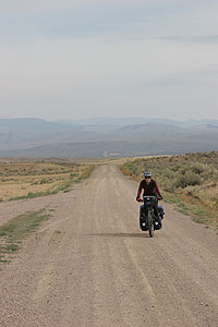 We’re traversing the Wild West out here: big wide gravel roads rolling through the sagebrush, hill after hill. After about an hour I feel warmed up, knees and all, and we make good progress. Today is all about climbing, and we set our sights on a big Divide crossing, Big Sheep Divide, which will take all day to attain. The sights slowly change from sage to bushes to trees, with a healthy sprinkling of cows throughout.
We stop about every hour to hour and a half to eat. We just keep eating and eating. I’m sort of amazed and horrified by the amounts of food I’m consuming.
We wind up a grassy river valley full of cows. As we approach groups of them on the road Dave commences to ringing the bell on his bike. If they’re very stubborn I ring mine as well. Cows are so stupid. Sometimes they’ll freak out and run straight ahead, stop, turn around and see you, and then get all freaked out and do the same thing again. What’s up with that?
We can see the pass up ahead for quite a while before we get there. We’ve been climbing gradually all day on rough roads, but soon the road steepens and gets rougher and looser. The last two or three miles are tough, but we stick to it and soon make it to the top. We congratulate each other on another good Divide crossing and put on some extra clothes for the reward: the descent. It’s getting windy and it’s just starting to sprinkle rain. We know from the map we’re just a few miles from our camp spot and we just can’t wait.
We start down and after only a few short minutes the road goes back up. It’s very hilly here and I think to myself, no biggie, it will go back down once we get over this hill. But no. We get over that hill and there’s another to climb. And another. And then it’s a gradual incline that looks to never end. We’re back in sagebrush cattle country and we don’t see any sign of the creeks that show on the map. We can camp anywhere now, we just need to find water to filter and we’ll be OK. We agree to stop as soon as we find some water.
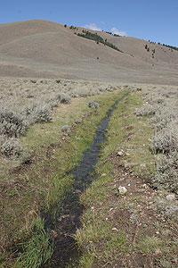 The turn indicated on our map as our stopping point finally appears. But there’s no clear sign of water and the road that goes to the lake looks to be longer than we can handle at this point. It’s late and really starting to rain now. So we head up the road to check it out and pass over a small creek. It’s completely hidden if you’re very far away from it, as it’s a small trough that runs through the sage with no other vegetation to indicate a riparian area. We quickly decide to camp right by this little dirt road and go about setting up camp. We’re really getting efficient at this now. But one thing we haven’t dealt with yet is cooking in the rain. There are no trees here at all, the rain is coming down and the wind is starting to howl. Dave whips out the spare tarp, brought just for such a time, and rigs up a porch for the tent using the bicycles and the tent to anchor it. It works great! Dave cooks up a great dinner and we’re warm and dry while it’s just crazy outside. Tonight we sleep well to the lullaby of rain on the tent.
comments off Post Categories: 2007 Great Divide Mountain Bike Route, Favorites, Montana
Comments are closed.